The 727 in environmental response
The Boeing 727 has become the platform of choice for rapid-response environmental operations. The trijet’s speed, endurance, and payload capacity position it to reach spill incidents quickly and carry the sensor and dispersant-spray equipment needed for effective response. Its established global support ecosystem and proven reliability make it dependable in time-critical situations.
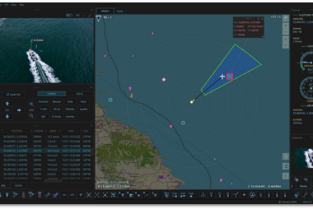
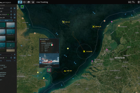
AIMS-ISR transforms the 727 from a data-collection asset into a full mission-management system. Where conventional approaches scatter imagery, GPS coordinates, and operational notes across separate tools, AIMS-ISR creates a single georeferenced operating picture. Crews see spill boundaries in real time, direct dispersant runs with precision, and generate evidence-grade recorded missions for regulatory review and inter-agency coordination.
AIMS-ISR on the 727
CarteNav has already integrated AIMS-ISR on the 727 airframe. The system is de-risked: we understand the 727’s flight envelope, sensor mounting points, and how its operational tempo translates into CONOPs. A program choosing the 727 inherits proven mission software that day one.
Spill-response operations depend on three capabilities AIMS-ISR delivers: mapping and evidence. AIMS-ISR records spill boundaries with georeferenced fidelity, creating audit trails for regulators and insurers. Coordination and command. AIMS-C4, our shore-based common operating picture, links air operations directly to response coordination centers, enabling real-time tasking and resource planning. Sensor flexibility. The system accepts data from multiple sensor suites without vendor lock-in, protecting your investment as environmental response evolves. This integration is part of CarteNav’s long record of putting mission software on the aircraft operators already fly.
Mission profiles
- Environmental response: Real-time spill detection, boundary mapping, and environmental-impact assessment with evidence-grade recording.
- Oil-spill response: Coordinated dispersant operations, multi-asset tasking via AIMS-C4, regulatory documentation.