CarteNav and our customers address today’s security, safety, economic, and environmental challenges. These challenges are complex and rapidly evolving.
We could tell you all about how we do it ourselves (see our latest case study). However, we wanted to instead shine the spotlight on some of our incredible customers and partners who have created videos that showcase our AIMS-ISR Mission Management System in action.
What does C4ISR Excellence Mean?
First, let’s remind ourselves what C4ISR stands for: Command, Control, Communications, Computers, Intelligence, Surveillance, and Reconnaissance. It’s a mouthful, but it’s four critical inputs required by operators to discover information that protects society and the environment.
Integrating today’s best command, control, communications, and computer technology is essential for maximizing operator’s situational awareness and information gathering abilities. However, it’s easier said than done – the requirements are in, the hardware is selected, now what?
Over the past twenty years, our team has worked with hundreds of integrators, sensor/platform OEMs, and operators to push the envelope on those four critical inputs powered by our software. So, to provide some inspiration for how it all comes together, we’ve selected a few of our favourite customer-made videos showcasing our AIMS-ISR mission system in action. Check back often or subscribe to our email newsletter below, as we will be regularly adding more videos.
Case Study Videos
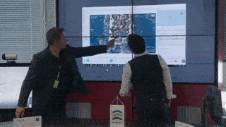
1. “Sea Operations – Multipurpose Aerial Surveillance,” by Frontex
The European Border and Coast Guard Agency, Frontex, provides a fantastic example of bringing all C4 components together for C4ISR excellence. The multi-role aircraft has multiple sensors equipped, including EO/IR and radar – attaining challenging targets while referencing additional moving maps data. The AIMS-ISR mission system unlocks collaborative capabilities for remote teams by streaming video and other data directly from the Mediterranean Sea to headquarters in Warsaw, Poland.
By leveraging the AIMS-ISR mission system within the aircraft and remote headquarters, a team of experts can rapidly make decisions for many operations, including surveillance, search & rescue, pollution events, IUU fishing, and other illegal maritime activities.
2. “C4ISR Aircrew Training for the New Zealand Defence Force,” by MAROPS
3. “UK Police using Kestrel MTI,” by Sentient Vision
Combining Moving Target Indication (MTI) with CarteNav’s AIMS-ISR augmented reality mapping system, Sentient Vision demonstrates the cost-effective situational awareness solution for the UK National Police Air Service (NPAS).
Fully integrated into AIMS-ISR, Kestrel Land MTI automatically cues operators to objects of interest such as moving people or vehicles. The increased situational awareness reduces operational burden. The increase in situational awareness enables operators to rapidly make decisions in regards to counterterrorism, routine patrol, and detecting suspects on the move.
4. “The SCAR-Pod Floats to Success!” by Airborne Technologies
Located at the Wiener Neustadt Airfield in Austria, Airborne Technologies (ABT) showcases versatility, innovation, and resilience by delivering 3 highly capable aircraft during the COVID-19 pandemic. The 3 Viking Air DHC 6-400 Twin Otters were converted into flexible ISR platforms by assembling two SCAR-PODs to carry the WESCAM MX-15 camera system, BMS Line of Sight Downlink, multi-channel data recorder, GETAC mission computer, and of course CarteNav’s AIMS-ISR augmented reality mission system software.
CarteNav provided integration support remotely for these 3 aircraft during the COVID-19 pandemic – including configuration completion, flight trial support, and refresher training.
5. “ViDAR VMS-5 pod helps save 24 migrants off the Belgium Coast” by Sentient Vision & Diamond
What was planned to be a customer flight demonstration, suddenly turned into a real-life Search and Rescue (SAR) mission. Approximately 15 minutes after takeoff, the DA42 MPP arrived at the search area, the windmill park. Due to the wide sweep width of the ViDAR Pod, the boat was found on its first pass. All 24 people in distress could be rescued after they were found in record time by the AIMS-ISR Equipped DA42 MPP Guardian.
Get the whole story here: CarteNav’s AIMS-ISR Onboard Diamond Aircraft’s DA42 MPP helps to save lives in the North Sea
6. “Turning Mobile Phones into Tracks with ARTEMIS” by Smith Myers
Footage captured from EC135 demonstration helicopter equipped and integrated by Nova Systems.
This demonstration showcases Smith Myers’ ARTEMIS Mobile Phone identification, geolocation and communication sensor as a game-changing system for search & rescue, disaster relief, and border security. ARTEMIS is integrated with AIMS-ISR to provide operators with cellular tracks geo-referenced on augmented reality moving maps alongside other equipped sensors such as active EO/IR track following.
Hungry for More C4ISR Excellence?
The CarteNav team is proud to work with world-class customers and partners worldwide on fast-paced security, environmental, and safety operations. As the development and innovation teams deliver software enabling C4ISR excellence, our team of photographers, writers, and videographers will capture the best related stories, news, and insights. For a more in-depth examination of AIMS-ISR in-use, check out our latest multi-mission Heliwest case study or subscribe below. We take cybersecurity seriously. You will only receive the very best stories, videos, and guides with your information remaining secure – you may unsubscribe at any time.