Halifax, Nova Scotia — Dec 9th, 2021 — CarteNav, the leading C4ISR mission platform for today’s complex surveillance operations, is pleased to announce the integration of MetOcean Telematics’ Iridium Self Locating Datum Marker Buoy (iSLDMB) with both AIMS-ISR for real-time mission management and AIMS-C4 for search and rescue (SAR) command & control in a Common Operating Picture.
The MetOcean Telematics iSLDMB is innovative, rugged, and compact to meet the stringent performance requirements of coastguards for Search and Rescue (SAR) operations in the open ocean. The buoy is deployed to communicate subsurface ocean currents and temperature in real-time – providing critical data to decision-makers tasked with rescuing a person, vessel, or aircraft lost at sea.
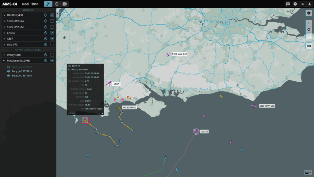
The MetOcean drift marker buoys are deployed by the aircrew and can now be tracked by the AIMS-ISR mission system. The drift marker buoys provide valuable data via the Iridium network to the onboard AIMS-ISR mission system – providing insight into the ocean environment. Tracking these buoys provide information to onboard operators to conduct the most effective search and rescue plan. The buoy data is displayed directly alongside other sensor data such as radar, AIS, and ViDAR – maximizing operator situational awareness and search effectiveness.
For rescue and search coordinators on the ground, AIMS-C4 provides the real-time and historical data from all deployed ISLDMB data in a Common Operating Picture. The use of real-time and historical data allows the rescue coordination centre to create SAR models and plans to achieve mission success.
“I am thrilled to announce the integration of MetOcean Telematics’ iSLDMB product with both AIMS-ISR and AIMS-C4 – together, they enable this crucial data to serve coastguard operators both in real-time and historically within a complete mission data lifecycle,” said Carl Daniels, COO of CarteNav. “The team is particularly pleased that together as geographic neighbours, we are bringing this new and dependable SAR solution to the global market, showcasing Atlantic Canada’s world-class development for ocean technologies.”
— Carl Daniels, CarteNav COO
“We are delighted to witness the successful integration of MetOcean’s iSLDMB with CarteNav’s mission critical platforms; AIMS-ISR and AIMS-C4. This collaboration will provide SAR operators with the full gamut of real-time data access during active missions, when data is critical, and lives are on-the-line. It was a true pleasure working with the team at CarteNav and we look forward to future opportunities where we can collaborate.”
— Tony Chedrawy, MetOcean CEO
About CarteNav
CarteNav, established in 2002, develops ISR Mission Software for security, safety, economic, and environmental operations. The Canadian-based team has built its reputation on embracing challenges others may avoid, such as integrating with the world’s most innovative sensors that extend the operator’s capabilities far beyond the status quo – achieving ISR capabilities for threats that are complex and without boundaries. And with over 500 customer installations in over 40 countries, CarteNav’s ISR Mission Software is built to be highly adaptable for meeting today’s diverse operational requirements.
To learn more, visit us online: CarteNav.com
About MetOcean Telematics
MetOcean Telematics corporate headquarters, including the research and development and production facilities, are in Dartmouth, Nova Scotia, Canada. The company develops and manufactures state-of-the-art data acquisition and end-to-end telematics solutions, with a focus on niche MetOcean solutions and custom Defence and Security products. As a prominent global Iridium Satellite Value-Added Reseller focused on hardware solutions, data services, and support, MetOcean Telematics is a leader in the satellite communications industry.
For more information, visit: metocean.com/defence/isldmb
Media Contact
Trevor Bradley
902-817-5233