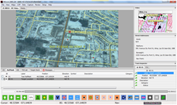
CarteNav Solutions Inc., the makers of situational awareness software solutions, today announced the release of version 7.0 of their AIMS-HD software, which includes a host of new features including Tactical Vision, the next generation of augmented reality tools for ISR.
“The power of our AIMS-HD software is that the user can customize it to suit the mission and the sensor suite. It simplifies the information flow to the user, streamlines their work cycle, and expedites the flow of intelligence to the customer.”
“We’ve made significant improvements to the core software, and added some really exciting new features,” said Scott Richardson, CarteNav’s VP of Product Development.
“Tactical Vision lets users add their own overlays and data onto the live video stream, which will significantly improve their situational awareness and overall effectiveness, no matter what the mission,” he continued.
“Imagine being able to plot your search area on top of the live video in a search and rescue mission, or having street address data available on a single interface in a law enforcement scenario – AIMS-HD now gives you the power to do all this and more, and all from a single interface.”
Another key new feature is Synchronized Mission Review. This allows the user to replay the captured video from the whole mission, automatically synchronized with the moving map and everything on it. What’s more, tracks, reference points and other marks and indicators can all be created from the review itself.
“The power of this is phenomenal”, said Mr. Richardson. “An operator has the opportunity to process all captured material after the mission or even at a remote location.” So, if something was missed, it can simply be added retrospectively, and the reviewing operator can easily see where the platform was and what the sensors were doing at any given time. To make things even simpler, the real-time operator can add event markers to the timeline to allow the reviewing operator to quickly focus on the times of interest.
Other key features include a higher resolution footprint, and a revised footprint calculation showing improved accuracy and the effects of terrain and aircraft attitude.
“The power of our AIMS-HD software is that the user can customize it to suit the mission and the sensor suite,” Mr. Richardson added.
He concluded, “It simplifies the information flow to the user, streamlines their work cycle, and expedites the flow of intelligence to the customer from the collection platform – whatever and wherever that may be.”
CarteNav’s software solutions are in use with customers all over the world and in a wide variety of applications from national defense, airborne intelligence collection, law enforcement, fire fighting, search and rescue, oil-slick monitoring, and infrastructure inspection.
CarteNav will be demonstrating this latest version of AIMS-HD at CANSEC 2014, booth 1831, on 28-29th May in Ottawa, and on 14-20th July at the Canadian Pavilion at Farnborough International Airshow in the UK.
About CarteNav Solutions Inc.
CarteNav Solutions Inc. is an international leader in situational awareness solutions for the airborne, land, and maritime environments. Founded in 2002, CarteNav offers operationally proven data integration and display technologies that dramatically improve performance of both sensor operators and tactical decision makers. The company has established a reputation for providing sought-after and high-value software solutions to meet short timeframes at attractive price points.
With over a decade of experience in the industry, CarteNav has achieved some notable successes. CarteNav’s products have been deployed on a variety of surveillance platforms around the world and have seen operational service in more than fifteen countries.
The company’s success is founded on its people and its dedication to continued innovation, guided by well thought-out and focused research and development. An ISO 9001:2008- registered company, CarteNav’s technical expertise in sensor management, graphical user interfaces, map technology, networking operators, mission review, and systems integration is underscored by an unwavering commitment to quality and customer service.