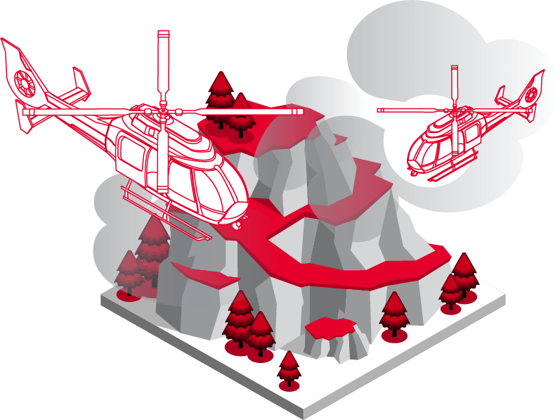
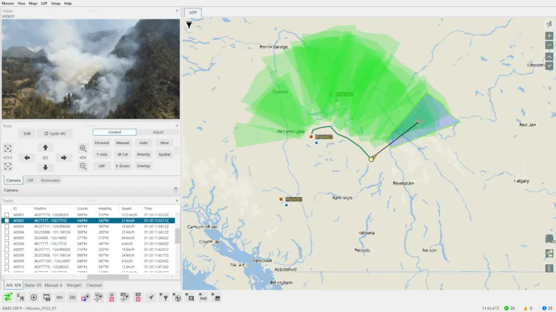
See Through Smoke with Intuitive Sensor Control
Track Wildfire Perimeters with Augmented Reality
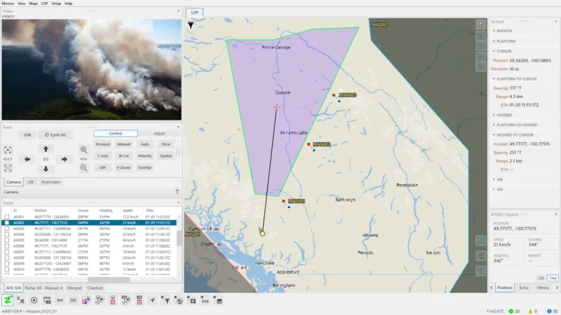
Report the Fire Situation to Every Team in Real-Time
Real-time Management Tools for the Entire
Aerial Firefighting Mission
Lifecycle
For real-time Aerial Firefighting operations in the field or mission management back at Command & Control – CarteNav provides C4ISR software covering the entire mission lifecycle.

Intuitive Control for
Multi-Role Aerial Firefighting Operators
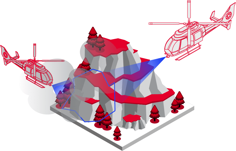
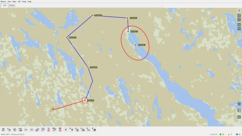
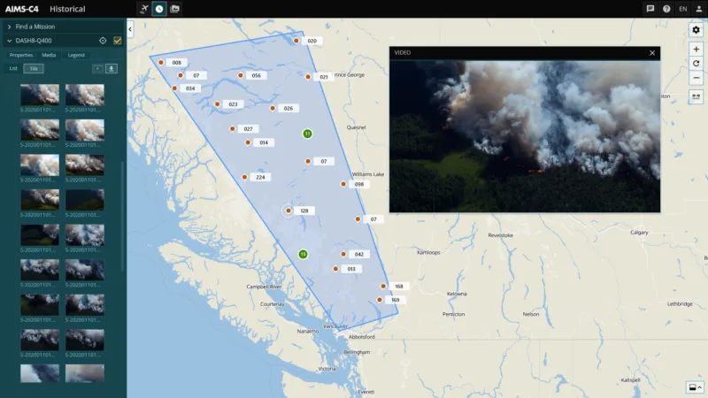
For firefighting operators in the field, AIMS-ISR provides firefighting reconnaissance planning, hidden hotspot identification, fire perimeter tracking, and fire situation reporting in an intuitive and flexible moving map interface.
Firefighting Reconnaissance Planning
Know before you go. Whether the reconnaissance flight starts with a suspicious smoke plume or an already raging wildfire, operators can immediately know where to look with imported waypoints shown directly on Augmented Reality Moving Maps. Custom mapping and data managers mean operators always know where to look and what critical infrastructure may be around them.
Time-Saving Capabilities for Routine Fire Patrol Spotters
For routine fire patrol, the augmented reality mapping engine can record EO/IR breadcrumbs on the moving map showing exactly where the spotter has already looked. Visual confirmation of where operators have already patrolled can be handed off between rotating crews – eliminating redundant spotting of the same areas.
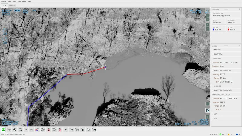
Fire Mapping that's as Fast as it is Accurate
AIMS-ISR's augmented reality mapping offers firefighting crews intuitive tools to see through the clouds and accurately map wildfires' perimeter. In real-time, reconnaissance operators can report the fire situation map and information such as acreage to crews and planners on the ground.
Intuitive and Easy to Use
AIMS-ISR is built with ease-of-use and maximum situational awareness so operators can tackle multiple concurrent incidents on a single mission without strain. Rotating fire reconnaissance crews with no previous system experience can quickly become proficient with minimal training.

Aerial Firefighting Mission
Planning & Management
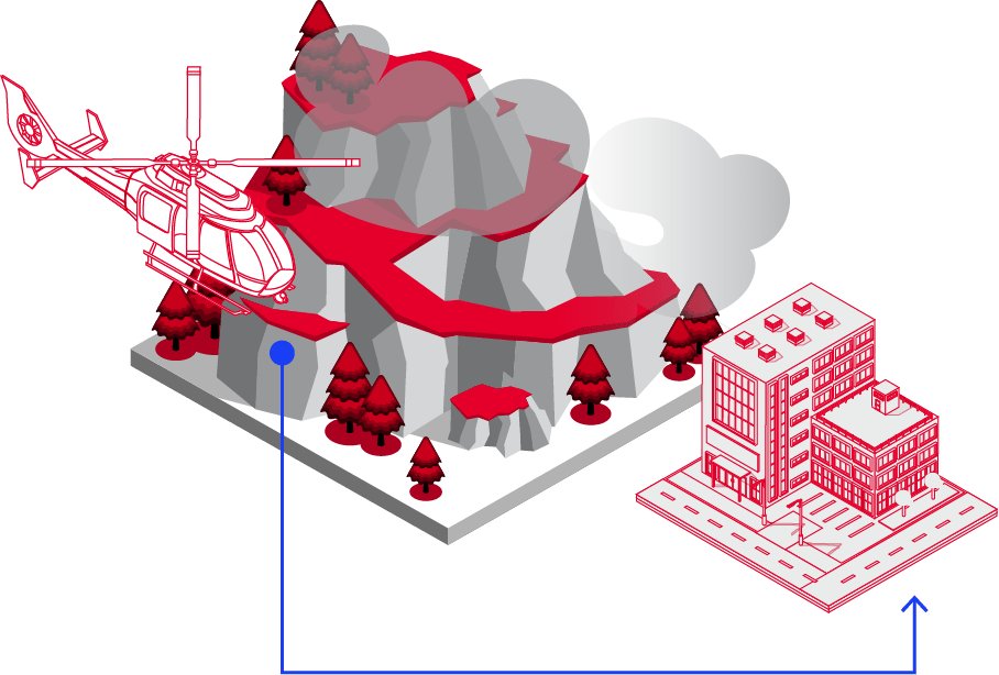
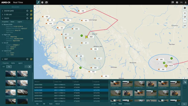
Firefighting missions can be frequent and concurrent, with each generating vast amounts of information. AIMS-C4 manages fire situations in one Common Operating Picture (COP) while collecting and storing mission data for review and analysis amongst a distributed team.
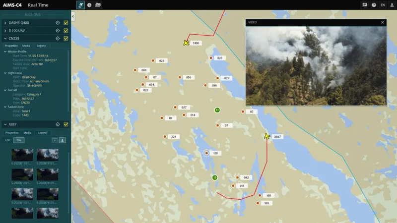
All Teams. All Fire Maps. One Operating Picture.
Manage reconnaissance in the air while feeding information to firefighters, command centre planners, and news media on the ground. AIMS-C4 is a single real-time Common Operating Picture (COP). Teams access this COP on any device via an intuitive web-based interface for rapid decision-making and maximum situational awareness.
Put Historical Geospatial Data to Work
Today's wildfire situations are volatile and fast-spreading. Daily reconnaissance generates vast amounts of imagery and geospatial fire tracking data. AIMS-C4 securely stores all gathered data to allow users to ask, "how has the situation changed day by day?" Or, "when was the last time this area was patrolled and by whom?" Or "show me post-fire damage imagery and video from this specific area for further analysis."
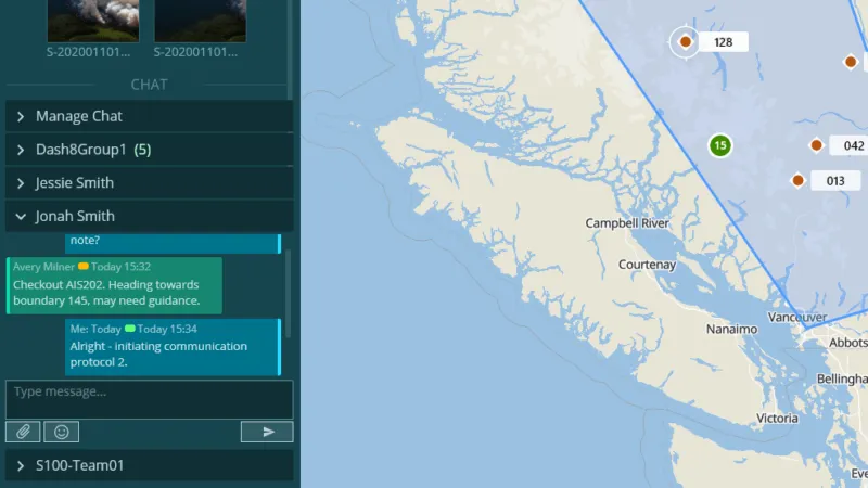
Real-Time Communication
Incident commanders have a direct communication line to aerial reconnaissance operators in the sky with live-chat and media sharing. Airborne operators can efficiently communicate the fire situation – establishing firelines & firebreaks.
Flexibility to Go Beyond Firefighting
AIMS-C4 is a flexible multi-INT platform configurable for operations beyond firefighting such as search & rescue, law enforcement, surveying, and much more. This flexibility is at the core of the complete mission lifecycle – ensuring every operator, platform, and sensor is maximized.
Customer Case Study
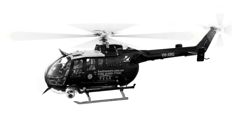
Heliwest Group
Located on Australia's rugged west coast, Heliwest provides highly accurate, real-time maps of the current fire situation to planners and firefighting teams on the ground. Other missions include search & rescue and linear surveillance – all executed using one common ISR mission system: AIMS-ISR.
"With AIMS-ISR, we can provide highly accurate, near-real-time maps of the current fire situation to planners and firefighting teams on the ground. Without it, that would be impossible."
Tim Hand, Manager of Special Projects, Heliwest
Going Beyond the Status Quo
Aerial Firefighting Operator
Situational
Awareness
For real-time operations in the field or mission management back at Command & Control – CarteNav provides C4ISR software covering the entire mission lifecycle.
Challenges Facing Aerial Firefighting Integrators & Operators |
CarteNav C4ISR Mission Software Solutions |
|---|---|
| A limited selection of OEM supported firefighting reconnaissance sensors. | The flexible plugin-based architecture of AIMS-ISR and AIMS-C4 support a wide array of sensors that allow operators to penetrate the smoke from multiple altitudes. |
| Lack of communication between airborne reconnaissance aircraft and ground teams. | Real-time chat and sharing of fire situation imagery in a Common Operating Picture (COP) for planners and firefighters on the ground. |
| Single-mission only solutions. | AIMS-ISR is a versatile Mission Management System that can support multi-role operations beyond firefighting such as search & rescue, maritime patrol, law enforcement, and much more! |
| Lack of custom mapping data for complex terrain and critical infrastructure considerations. | Ability to import custom mission data, including zones, Points of Interest, address database, mapping, routes, and more. |
What's Your Aerial Firefighting Mission?
CarteNav’s ISR Mission software is ready for integration with your Aerial Firefighting operation and chosen multi-sensor configuration – backed by a dedicated ISR support & training team. Schedule a demonstration today and discover the future of Aerial Firefighting.
Schedule Demonstration