
Hardware Agnostic Mission System Software to Power Today's Multi-Role ISR Solutions
Air, land, or sea – operators around the globe rely on AIMS-ISR for multi-sensor control, geo-referenced moving maps, evidence reporting, SIGINT, custom mapping, and more – all with unprecedented flexibility & ease of integration.
Get Started
Intelligence Gathering
For Today's Missions

Integrate
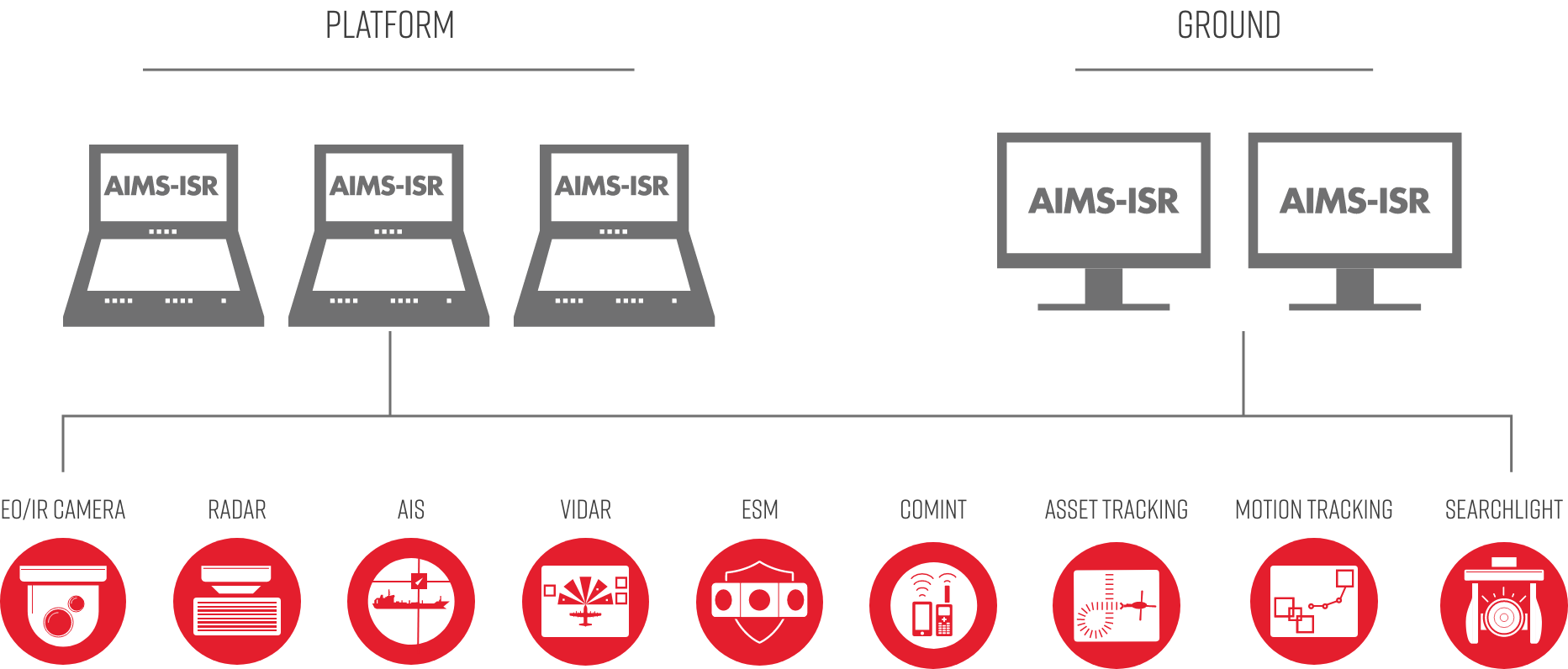
Plugin architecture allows for mission flexibility of any sensor integrated on your chosen platform.
Plan
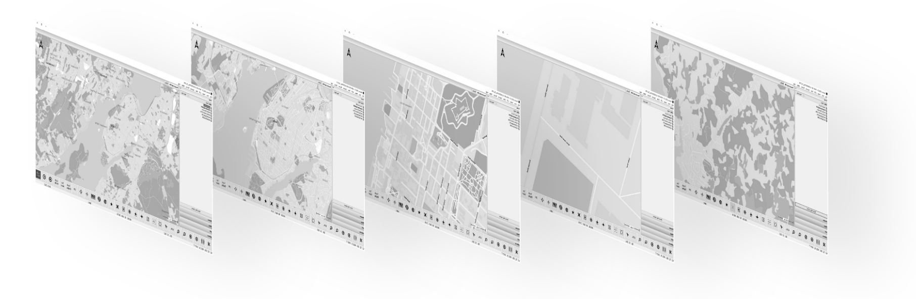
Interactive geo-referenced Moving Maps for planning, execution, and review of ISR mission data.
Gather
Complete and integrated control of primary and secondary mission sensors including Radar, EO/IR, ViDAR, AIS and more.
Share
Share ISR data products across the enterprise in real-time, or post-mission with rapid report generation.
Cover Twice the Distance
Cut Mission Time In Half
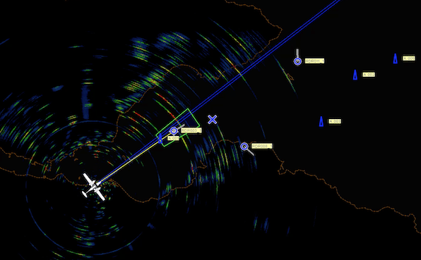
There’s a reason AIMS-ISR is a preferred choice by special mission operators around the world. Geo-referenced data overlays from multiple sensors paired with intelligent annotations, filters, and alerts enable operators to immediately establish and maintain focus on Targets of Interest (TOI) – gathering data quickly & accurately when every second counts.
TacVision
Augmented Reality Tactical Overlay displays Point of Interest (POI) markers, Boresight Address, Street labels, in-video measurement tools, perimeter mapping, and Areas of Interest on top of live sensor video enable maximum situational awareness when every second counts.
Kestrel Moving Target Indicator (MTI)
With support for Land, Maritime, and SAR modes, Kestrel Land & Maritime MTI enables operators to harness artificial intelligence to automatically identify moving targets or small objects requiring just EO/IR full-motion video. Increase visibility of difficult targets and follow breadcrumbs to track historical movement – improving wide-area coverage & aiding fatigued human eyes.
Alerts & Filters
Increase situational awareness with custom alerts utilizing a variety of rules to alert operators of specified actions or deviations.

Smart filters are a powerful tool for removing irrelevant mission data and tracks. By creating custom rules based on range, zone, track speed, and more, operators can narrow the breadth of information shown for rapid dissemination of relevant mission data.
Multi-Cue Lock.
Auto Sensor Control.
AIMS-ISR goes beyond intuitive on-screen buttons and physical controllers. Multi-Cue Lock tracking automatically keeps the cameras, radars, and other sensors focused on the Targets of Interest. Select target tracks from radar and signals intelligence data integrations – AIMS-ISR will slew to the selected track and follow as the position is updated.
Multi-Mission
Radar
Detect and track multiple targets across large areas directly in the Local Operating Picture (LOP) with full multi-mission radar support. Having the radar fully integrated with the LOP allows compact interfaces with a minimum sensor operating crew of just one – resulting in unmatched situational awareness & cost savings.
“With AIMS-ISR, we can provide highly accurate, near-real-time maps of the current fire situation to planners and fire-fighting teams on the ground. Without it, that would be impossible.”
Tim Hand, Manager of Special Projects, Heliwest
Get Case Study
Multi-Layer Moving Maps for
Today's Multi-Role Operations
AIMS-ISR offers a powerful Terrain Corrected moving maps platform that combines the data from equipped sensors with all equipped charts, 3D Terrain data, custom overlays, addresses, and POI databases. Relevant information at your fingertips.
Focus situational awareness by filtering out irrelevant objects based on range, zone, speed, and more.
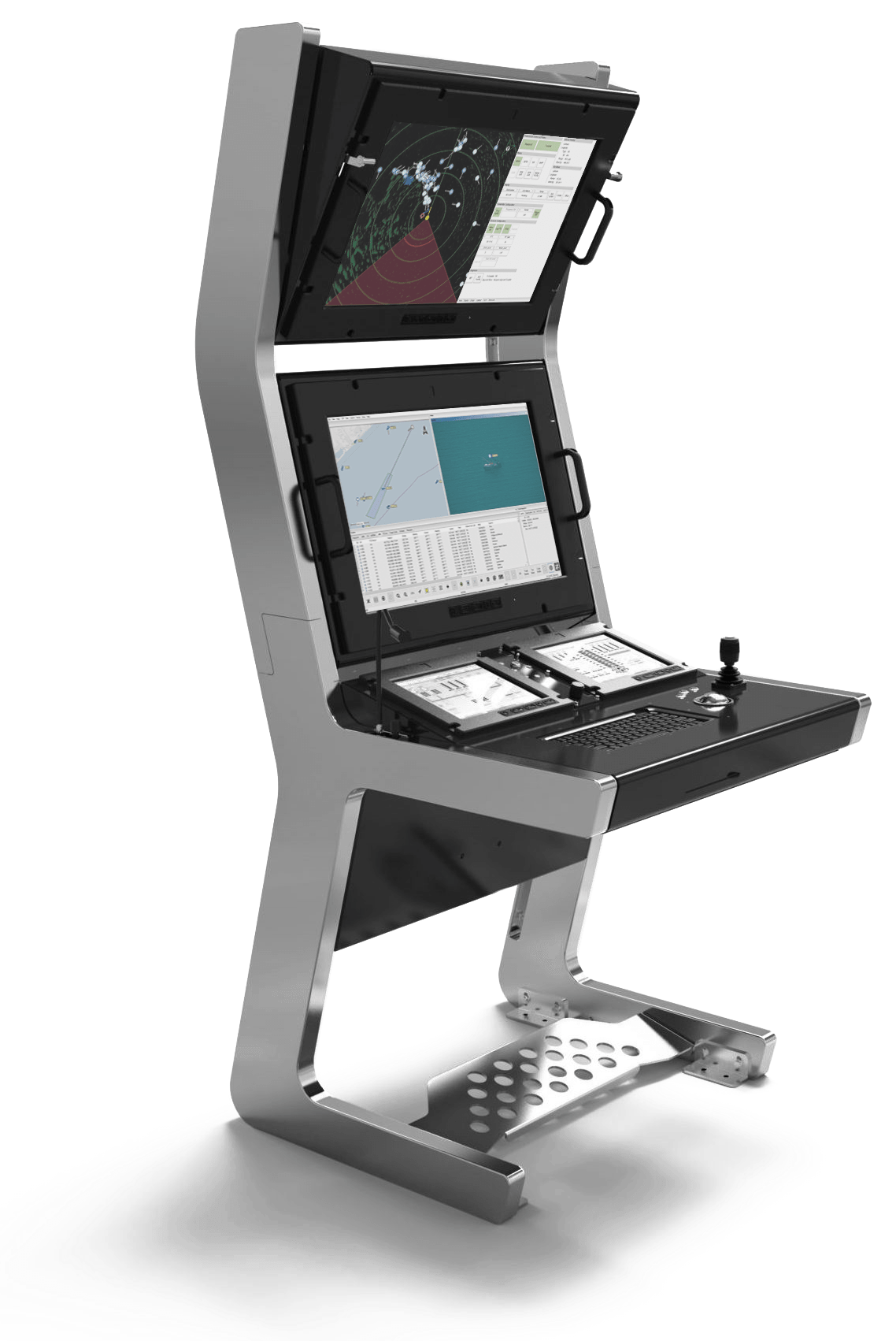
Any Platform / Any Sensor / Any Mission
The operator’s mission requirements always come first. That’s why AIMS-ISR utilizes a unique modular plugin architecture for intuitive sensor interfaces that never get in the way – enabling maximum flexibility to system integrators & their customers.
Custom Workspaces for Each Crew Role.
Maximum Control.
Configure the AIMS-ISR workspace to fit any screen or mission type – including an optimized touchscreen mode for tablets and touch consoles.
Real-time Communication & Collaboration
Whether on sea, land, or air – AIMS-ISR makes multi-station operator networks easy with real-time mission data sharing and client interfacing. Additional operator stations can be located on the platform and in a Command and Control centre – enabling efficient dissemination of mission information & rapid decision making.
At a Glance
-
Data Gathering
- Target of Interest (TOI) Tracking
- EO/IR Moving Maps Footprint
- TacVision
- Classification & Mission Progress Status
- Perimeter Mapping
- Auto EO Snapshots
-
Mission Planning & Review
- Custom Mission Data & Databases
- Post-Mission Report Generation
- Mission Media Viewer & Editor
- Interactive Mission Review
- KLV Metadata for 3D Post-Mission Debrief
-
Situational Awareness
- Alerts & Filters
- Custom Moving Map Manager
- Historical Breadcrumbs
- Kestrel Moving Target Indicator (MTI)
- Navigational Aids & Routes
- Target Velocity Measurement
- Delineation of EEZ Boundaries
-
Sensor Control
- Auto EO/IR Multi-Cue Lock
- Multimode Surveillance Radar
- ViDAR
- Searchlight Control
- SIGINT/COMINT/ELINT
- ADS-B
- AIS
-
Ease of Integration
- Platform/Sensor/Hardware Agnostic
- Custom Dynamic Workspaces
- ITAR Free
- Surface Mode Capture
- Low-Bandwidth RPAS Transmission
- Multi-station Network for Team Collaboration
- Commercial Off the Shelf (COTS) Software
Mission Systems. Solved.
Defence ISR
Search & Rescue
Maritime Patrol
Fire Fighting
IUU Fishing
Law Enforcement
Pollution Control
Border Security
What's Your Mission?
AIMS-ISR is ready for integration with any sensor on any platform – backed by a dedicated ISR support & training team. Schedule a demonstration today and put AIMS-ISR to the test for your mission.
Schedule a Demo